-
【openlayers】地图【一】

基本概念
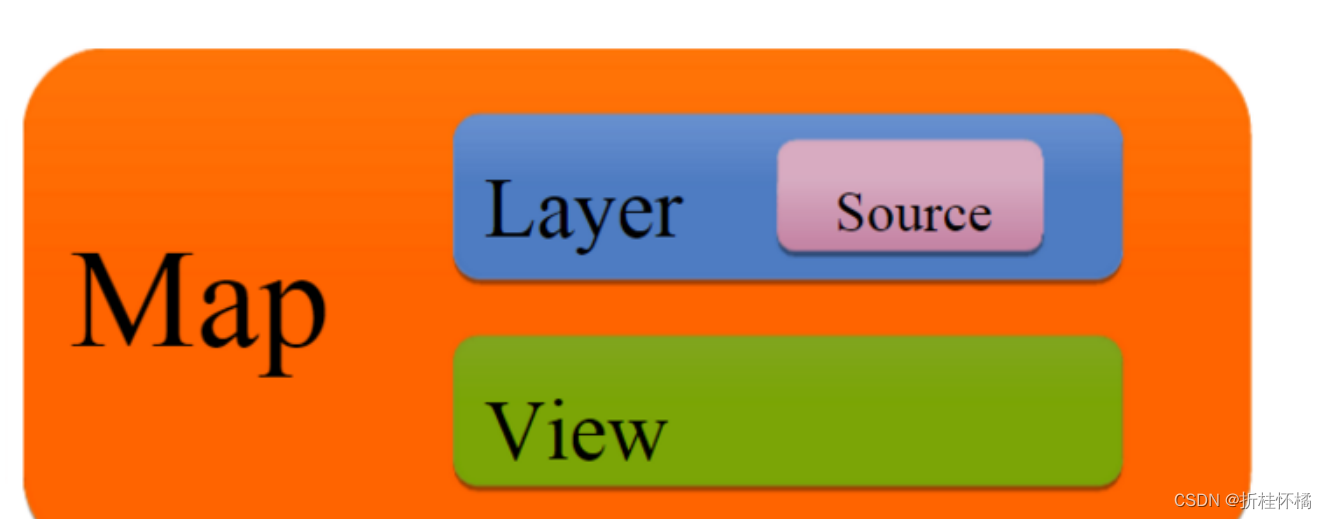
Map地图
OpenLayers的核心组件是map(ol/map),被呈现到目标容器当中(例如,包含地图的网页上的div元素);所有的地图元素要么在构造时配置所有映射属性
下面的标记可用于创建包含地图的 div 元素:
<div id="map" style="width: 100%, height: 400px"></div>- 1
- 2
View视图图层
View是指地图视图图层,包括中心点、缩放等级、分辨率等数据都是依赖图层去展示的;
import View from 'ol/View'; map.setView(new View({ center: [0, 0], zoom: 2 }));- 1
- 2
- 3
- 4
- 5
- 6
Source数据源
为了获取层的远程数据,OpenLayers使用ol/source/source子类。这些可用于OpenStreetMap或Bing等免费和商业地图平铺服务、WMS或WMT等OGC源以及GeoJSON或KML等格式的矢量数据。
import OSM from 'ol/source/OSM'; var osmSource = OSM();- 1
- 2
- 3
Layer图层
图层是源数据的可视化表示形式,OpenLayers有四种基本类型的层:
-
ol/layer/Tile:瓦片图层——平铺-渲染网格中提供平铺图像的源,网格按特定分辨率的缩放级别组织。
-
ol/layer/Image:图像——渲染以任意范围和分辨率提供地图图像的源。
-
ol/layer/Vector:矢量图层——在客户端呈现向量数据。
-
ol/layer/VectorTile:矢量瓦片——作为矢量分幅提供的数据呈现。
import TileLayer from 'ol/layer/Tile'; var osmLayer = new TileLayer({source: osmSource}); map.addLayer(osmLayer);- 1
- 2
- 3
- 4
vue openlayers应用
<template> <div> <div class="ol-map" ref="olMap"></div> <!--可以给元素设置一些样式--> <div class="ol-popup" ref="olPopup">{{ olPopupText }}</div> </div> </template> <script> import Map from "ol/Map"; import View from "ol/View"; import { Tile as TileLayer } from "ol/layer"; import { OSM, XYZ, WMTS } from "ol/source"; import { fromLonLat } from "ol/proj"; import { defaults as defaultInteractions, DragRotateAndZoom, } from "ol/interaction"; import { defaults, FullScreen, MousePosition, ScaleLine } from "ol/control"; import Overlay from "ol/Overlay"; import { Vector as VectorLayer } from "ol/layer"; import { Vector as VectorSource } from "ol/source"; import { Style, Icon } from "ol/style"; import Feature from "ol/Feature"; import Point from "ol/geom/Point"; import { Translate } from "ol/interaction"; import { Draw } from "ol/interaction"; import GeometryType from "ol/geom/GeometryType"; import { createRegularPolygon, createBox } from "ol/interaction/Draw"; import { Modify } from "ol/interaction" export default { name: "exm1", data () { return { olPopupText: "default text" } }, created () { }, mounted () { // 使用内置的osm // const tileLayer = new TileLayer({ // source: new OSM() // }); // 使用 天地图 的瓦片数据 // const tileLayer = new TileLayer({ // source: new XYZ({ // url: "http://t0.tianditu.gov.cn/img_w/wmts?SERVICE=WMTS&REQUEST=GetTile&VERSION=1.0.0&LAYER=img&STYLE=default&TILEMATRIXSET=w&FORMAT=tiles&TILEMATRIX={z}&TILEROW={x}&TILECOL={y}&tk=9b21fa580b77ebbb20ee6245e2fc96eb" // }) // }) // ??? 如何加载 wmts 服务, 下面有问题代码 // const tileLayer = new TileLayer({ // source: new WMTS({ // url: "http://t1.tianditu.gov.cn/vec_c/wmts?tk=9b21fa580b77ebbb20ee6245e2fc96eb" // }) // }) // 使用 高德 的瓦片数据 const tileLayer = new TileLayer({ source: new XYZ({ url: "https://webrd01.is.autonavi.com/appmaptile?lang=zh_cn&size=1&scale=1&style=8&x={x}&y={y}&z={z}", }), }); let map = new Map({ layers: [tileLayer], view: new View({ center: fromLonLat([120.771441, 30.756433]), // 地图中心点 zoom: 15, // 缩放级别 minZoom: 0, maxZoom: 18, constrainRotation: true, // 因为存在非整数的缩放级别,所以设置参数true来让每次缩放结束后自动缩放到距离最近的一个整数级别,这个必须要设置,当缩放在非整数级别时地图会糊 }), target: this.$refs.olMap, controls: defaults().extend([ new FullScreen(), // 显示全屏 new MousePosition(), // 显示鼠标当前位置的经纬度 new ScaleLine(), // 显示比例尺 ]), }); map.on("click", (e) => { console.log("地图点击", e); }); }, }; </script> <style scope> .ol-map { height: 90vh; } .ol-popup { width: 40px; height: 30px; font-size: 14px; text-align: center; } </style>- 1
- 2
- 3
- 4
- 5
- 6
- 7
- 8
- 9
- 10
- 11
- 12
- 13
- 14
- 15
- 16
- 17
- 18
- 19
- 20
- 21
- 22
- 23
- 24
- 25
- 26
- 27
- 28
- 29
- 30
- 31
- 32
- 33
- 34
- 35
- 36
- 37
- 38
- 39
- 40
- 41
- 42
- 43
- 44
- 45
- 46
- 47
- 48
- 49
- 50
- 51
- 52
- 53
- 54
- 55
- 56
- 57
- 58
- 59
- 60
- 61
- 62
- 63
- 64
- 65
- 66
- 67
- 68
- 69
- 70
- 71
- 72
- 73
- 74
- 75
- 76
- 77
- 78
- 79
- 80
- 81
- 82
- 83
- 84
- 85
- 86
- 87
- 88
- 89
- 90
- 91
- 92
- 93
- 94
- 95
- 96
- 97
- 98
- 99
- 100
- 101
- 102
-
相关阅读:
AI :微软推出 AutoGen 框架,帮开发者创建基于大语言模型的复杂应用
选择排序、冒泡排序、快速排序、归并排序
小程序容器助力车企抢滩智慧车载新生态
一、CSS定位布局[相对定位、绝对定位、固定定位]
pip配置多个国内的python镜像源
“蔚来杯“2022牛客暑期多校训练营9 G题: Magic Spells
一文总结你需要的OpenCV操作
第三方支付功能测试点【杭州多测师_王sir】【杭州多测师】
docker 常用
单例模式之「双重校验锁」
- 原文地址:https://blog.csdn.net/weixin_42910765/article/details/126039587
