-
geopandas 笔记: datasets 数据集
geopandas 自带的几个数据集
1 世界各个国家
- import geopandas as gpd
- import pandas as pd
- pd.set_option('display.max_rows',None)
- gpd.read_file(gpd.datasets.get_path('naturalearth_lowres'))

pop_est 人口数量 continent 国家所在的大陆 name 国家的名称 iso_a3 国家的三个字母的ISO代码 gdp_md_est 国家的估计GDP(以百万为单位) geometry 国家的地理边界。这可以是POLYGON(多边形)或MULTIPOLYGON(多个多边形的集合,常用于有多个岛屿的国家) 2 世界主要城市
gpd.read_file(gpd.datasets.get_path('naturalearth_cities'))
3 纽约的几个行政区域
gpd.read_file(gpd.datasets.get_path('nybb'))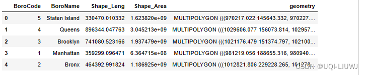
-
相关阅读:
骑士周游 ---递归的说明
黄子韬直播风暴揭秘经济人风波
基于 Rainbond 的 Pipeline(流水线)插件
平均负载与 CPU 使用率,到底有啥区别?
虚拟内存技术的基本概念(局部性原理,特征,实现)
AQS:Java 中悲观锁的底层实现机制
【分享】集简云小程序识别财务票据同步到金蝶云星辰流程搭建示例
程序员疯抢的 Java 面试宝典(PDF 版)限时开源,别把大厂想的那么难,关键是你准备得如何
C51--串口
css预编语言sass使用语法详解
- 原文地址:https://blog.csdn.net/qq_40206371/article/details/132757846