-
ouster-32激光雷达使用---雷达输出数据分析
雷达输出数据分析
所有数据
查看当前topic消息种类
rostopic list- 1
终端输出
/clicked_point /initialpose /move_base_simple/goal /os_node/imu_packets /os_node/lidar_packets /ouster/imu /ouster/imu_packets /ouster/lidar_packets /ouster/nearir_image /ouster/os_nodelet_mgr/bond /ouster/points /ouster/points2 /ouster/range_image /ouster/reflec_image /ouster/signal_image /rosout /rosout_agg /tf /tf_static- 1
- 2
- 3
- 4
- 5
- 6
- 7
- 8
- 9
- 10
- 11
- 12
- 13
- 14
- 15
- 16
- 17
- 18
- 19
imu数据
可以看到ouster 是带有内置imu的
imu消息的名称是 /ouster/imu
查看其消息类型:rostopic info /ouster/imu- 1
终端输出
Type: sensor_msgs/Imu Publishers: * /ouster/os_nodelet_mgr (http://JKKC:38655/) Subscribers: None- 1
- 2
- 3
- 4
- 5
- 6
雷达数据
查看点云数据类型
rostopic info /ouster/points- 1
终端输出
Type: sensor_msgs/PointCloud2 Publishers: * /ouster/os_nodelet_mgr (http://JKKC:41713/) Subscribers: * /rviz (http://JKKC:37099/) * /ouster/os_nodelet_mgr (http://JKKC:41713/)- 1
- 2
- 3
- 4
- 5
- 6
- 7
- 8
查看点云标签
rostopic echo /ouster/points/fields- 1
其中一包数据为:
- name: "x" offset: 0 datatype: 7 count: 1 - name: "y" offset: 4 datatype: 7 count: 1 - name: "z" offset: 8 datatype: 7 count: 1 - name: "intensity" offset: 16 datatype: 7 count: 1 - name: "t" offset: 20 datatype: 6 count: 1 - name: "reflectivity" offset: 24 datatype: 4 count: 1 - name: "ring" offset: 26 datatype: 2 count: 1 - name: "ambient" offset: 28 datatype: 4 count: 1 - name: "range" offset: 32 datatype: 6 count: 1 ---- 1
- 2
- 3
- 4
- 5
- 6
- 7
- 8
- 9
- 10
- 11
- 12
- 13
- 14
- 15
- 16
- 17
- 18
- 19
- 20
- 21
- 22
- 23
- 24
- 25
- 26
- 27
- 28
- 29
- 30
- 31
- 32
- 33
- 34
- 35
- 36
- 37
- 38
- 39
- 40
- 41
- 42
- 43
- 44
- 45
- 46
所以在雷达数据中的标签有:
- x
- y
- z
- intensity
- t
- reflectivity
- ring
- ambient
- range
坐标系
在该驱动文件中,启动rviz后,默认有3个tf

- os_imu
- os_sensor
- os_lidar
这3个方向是不一致的,其中
- os_imu 和 os_sensor 是以连接点的对面为x轴,左为y轴,上为z轴,满足右手定则
- os_lidar 是以连接点的方向为x轴,左为y轴,上为z轴,满足右手定则
os_lidar 坐标系
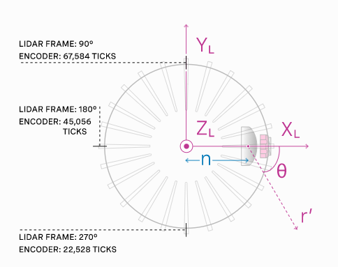
os_sensor 坐标系

Rviz显示
驱动包默认的rviz显示

其中包含了
- 根据反射率转换成的类似红外图像的图片 reflectivity
- 将距离转成图形的深度图 range
- 点云 PointClound2
- TF
-
相关阅读:
数据库与身份认证
ElasticSearch中全文搜索(单词搜索、多次搜索、组合搜索和权重搜索)
常用技能点:Java中数组复制的三种方式
【低代码】角色和权限的解决方案
【学习笔记】HQL
常见vue问题
C#的类型转换
ubuntu安装opencv4.7.0
【无标题】
金仓数据库 KingbaseES 异构数据库移植指南 (4. 应用迁移流程)
- 原文地址:https://blog.csdn.net/qq_32761549/article/details/128097999